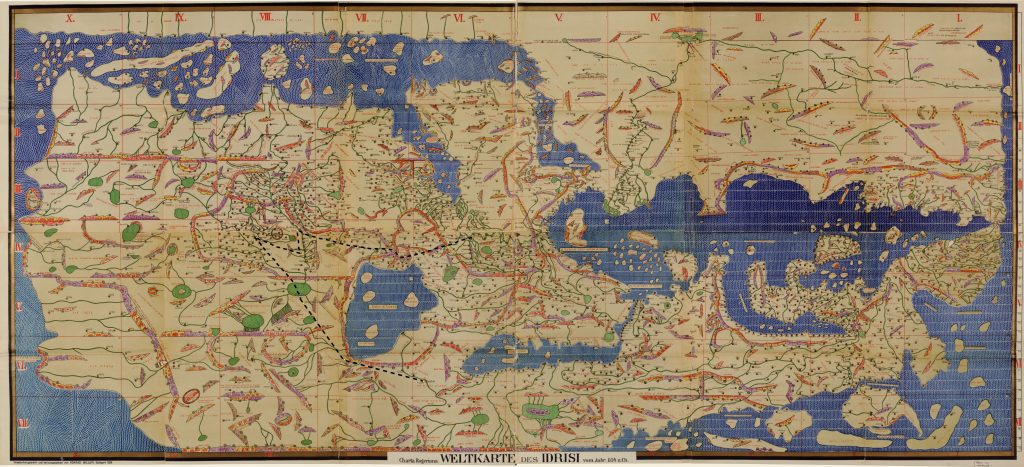
The Arabic cartographic tradition, which drew upon and transmitted the cartography of Ptolemy, a Greek geographer and astronomer of the second century, projected the spherical world onto a plane, which was then divided into grids.
The longitudinal bands were called “climes” and the latitudinal bands, “sections.” The intersection of the fifth section with the first clime brings us to the edge of our knowledge. The equator serves as the southern limit, which, as is often the case with medieval Arabic maps, features on the top of the page. The river that starts beyond the line and runs to the north (i.e., toward the bottom of the page) is a tributary of the Nile. To the left we can make out the bottleneck of the Red Sea that forms the Bab al- Mandab Strait, and, to the south, the Indian Ocean. The points in the shape of rosebuds are localities. We should be on familiar ground here: this map comprises what al- Idrîsî knew about the region that for us constitutes the northeast corner of Africa.
And yet we recognize almost nothing. Has human geography changed so much that only the names Allâqî, a mountain in southeastern Egypt known for its gold mines; the Beja, a pastoral people of Sudan and Eritrea; and Abyssinia still mean anything to us? Or is the information on this map simply fantastical? It is true that al- Idrîsî, a cartographer of Andalusian and Maghrebian ancestry in the service of a Latin Christian sovereign, Roger II, Norman king of Sicily, and who had certainly never traveled farther than Spain, Morocco, or, perhaps, Provence and Italy, was not necessarily well informed about these remote regions.
It has often been noted, with regard to other regions, that he relied on sources that were one or two hundred years old; it has even been thought that some of the mangled toponyms on his maps were borrowed from Ptolemy. Be that as it may, provided that we are in a position to date these borrowings, we are curious to know to which reality the names on the map and in “the Book of Roger” (Kitāb Rujār), which is in a way its libretto, corresponded. Two zones are particularly interesting: first, the region between the river and the mountain, where the names of several localities appear; and second, the coastal fringe of the Gulf of Aden with its string of ports. Obviously, if we succeed in finding the key to this map, there would be sufficient material to bring a little clarity to this region (basically what we today call the Horn of Africa) that, in this period (let’s say from the eleventh to the middle of the twelfth century), is more or less completely obscured from us.
But it’s rare, as far as historical documents are concerned, for there to be a unique key, or even some intellectual tool that is truly able to act as a key. Failing that, let’s attempt to force the lock. On the right side of the page, two parallel sets of mountains define three regions arranged from north (bottom) to south (top), which correspond to the eastern Egyptian desert, the plain from Sudan to Eritrea, and finally “Abyssinia,” a vague term. However, the presence of a river delineating the northern horizon of the latter region and flowing to the west leaves little doubt that we are on the high central plateau of Ethiopia, precisely inclined toward the west and serving as catch basin to the Nile.
We should perhaps not draw too much attention to the lake and deserts mentioned beyond the equator, fictive evocations. Moreover, no locality is identified on the left bank of the river that, given the map’s apparent logic, is certainly not the Sudanese Nile or the Blue Nile, but more likely an evocation of the upper Takkazé, a powerful river whose waters carved the continent’s deepest canyon and which continues into Sudan where it joins the Atbarah River, a tributary of the Nile. Had we been dropped blind into this part of al- Idrîsî’s map, we would thus find ourselves in the Tigray Region of Ethiopia and neighboring districts to the south and east. But we don’t know any more than that. It’s a shame, for it should be acknowledged that the information transmitted by the geographer from Palermo originated during the period of Ethiopia’s dark centuries.
Of the string of ports that spread from Zâligh in the direction of the ocean, not one is named (on the map) or described (in the libretto) in such a way as to evoke for us a precise place. However, we are at least following the coast of present- day Somaliland, the northern part of the Horn, where each rosebud, equidistant between the ones preceding and following it, seems to evoke the stopovers of a maritime itinerary. This means that al- Idrîsî’s informant, unlike whoever informed him about the highland, would have been a sailor. But are we really where we think we are? In place of Zâligh, the commentators wanted to read Zeyla, which was not yet the great commercial port it would be between the thirteenth and the nineteenth century, and which today is a sleepy shantytown at the end of the Gulf of Aden. A convenient identification if we wish to focus only on the two common letters in the names of these cities and their identical position on the bottleneck of Bab el- Mandeb.
Even so, there is still something not quite right: in the text that accompanies the map, the Zâligh of al- Idrîsî is sometimes clearly situated on the edge of the Red Sea, in the land of the Beja, and from this “maritime city of Abyssinia” it was a two weeks’ journey to the uplands, which is strictly impossible from present- day Zeyla. In order to resolve these contradictions, Zâligh must be split in two and the information that has been associated with it disassembled. We are thus dealing with two localities, close enough in name and distance for the geographer to have confused them. The first is our Zeyla, the initial stopover on the voyage into the Indian Ocean in the direction of the equator. The other belongs to the geography of the Red Sea and the spaces that unfold from Egypt to Abyssinia; perhaps it’s Dahlak, an archipelago off the Eritrean coast, or else some littoral har-bor from where one could then reach the Ethiopian interior, that is, the Abyssinian highland.
Two distinct geographies meet on this map: one is the area around the Red Sea, a sort of distant annex of the Mediterranean; the other, past the Bab el- Mandeb bottleneck, is another world entirely. When these two geographies were mentally stitched together, two ports on the borders of their respective worlds found themselves conflated in the seam.